HelioMaps Join the beta

Best blinds, next 24 hours

A smarter app that shows its work.

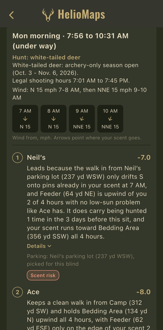
One sit from a Best blinds report: Monday morning, 7:56 to 10:31 AM, with Texas season and legal shooting hours, wind N then NNE at 15 mph from 7 to 10 AM, the top blind, Neil’s, at −7.0 with its whole note, and the start of the next, Ace, at −8.0.
  1. A: The sit and its hours. Each morning and evening sit is ranked on its own.
  2. B: Wind by the hour, from the National Weather Service forecast. The arrows point where your scent goes.
  3. C: Higher is better. It ranks stands for this sit only; it is not a chance of success.
  4. D: Yards and compass points in a note have to match the phone's own facts.
On a test ranch in Texas

Your phone ranks your stands for every sit in the next 24 hours, and your walking routes by how much each would disturb the ground you hunt. The reasons come in yards and hours.

Free: offline maps across the US. Pro: 2 Best blinds and 2 route reports a month. Scout: 30 of each.

Downloads are paused while a new version is posted. Email for an invite code.

Email for an invite code

The note

The numbers behind the note

This is the note on Neil’s, the top blind in the report above. Each number and compass point in it is marked.

Leads because the walk in from Neil’s parking lot (237 yd WSW) only drifts S onto pins already in your scent at 7 AM, and Feeder (64 yd NE) is upwind of you 2 of 4 hours …

From a real report on a test ranch Marked: 237 yd, WSW, S, 7 AM, 64 yd, NE, 2, 4 hours
  1. 1 Your phone

    Your phone ranks the stands by fixed rules.

  2. 2 AI

    AI (Claude, by Anthropic) writes the note from the phone's facts and cannot change the order.

  3. 3 Every number checked

    Every number and compass point in a note (marked here) has to match those facts, or the note is thrown out and the facts are shown instead.

In the app, tap Details to see every fact and every part of the score. Route reports are written the same way.

Inputs

What the phone weighs

Best blinds ranks your blinds and stands (ladder stands, tree stands, pop-up blinds and glassing points too) on these inputs, one sit at a time.

  • Wind

    Where your scent goes in each hour of the sit, from the National Weather Service hourly forecast. Calm hours are not judged.

  • Thermals

    In wind of 5 mph or less, air sinking or rising by the clock carries your scent onto pins at least 10 ft below or above the stand.

  • Your pins

    Feeders and food plots within 300 yd of the stand; funnels, water, scrapes and rubs within 400 yd; bedding within 800 yd.

  • The walk from parking

    A straight line from the stand's parking spot, judged at the hour you walk in, 30 minutes before the sit. Scent on feeders, food plots or bedding, passing within 100 yd of them, long walks and driving close all count against a stand.

  • Feed times

    Pair a HelioTimer Pro (coming soon), and a feed during the sit counts for a stand when your scent is off the feeder. A feeder that has been skipping feeds counts less.

  • The rest

    Forecast fog, a low sun in your eyes, a wind that swings during the sit, how often the stand was sat in the last 3 days (from your hunt assignments), and the rut.

Each report also says what it leaves out:

Not checked: neighbours, cover and terrain between you and the pins. The wind on the ground wins.

What the app says in its Best blinds reports

In numbers

  • 25 mEvery 25 m (about 27 yd) of the walk judged at the hour you would reach it (route reports)
  • 5Up to 5 walking routes compared (route reports)
  • 8 sidesGround heights checked 328 yd out (approach wind)
  • 6.2 miLine of sight on bare ground, from eye level or from a ladder or tree stand with your eye about 19 ft up (Scout)
  • 24 hEvery morning and evening sit in the next 24 hours (Best blinds)
  • 2,913Counties with rut dates

Getting to the stand

The walk in

Your walking routes, ranked by how much each would disturb the ground you hunt, and the sides you can come in from, hour by hour.

Pro and Scout

Which way in
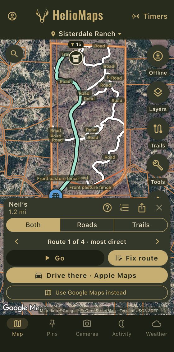
A ranch map over satellite imagery with the route drawn in green from a gate at the bottom, along the ranch's roads and a trail, to the blind at the top. The sheet below shows Neil’s, 1.2 mi, Both, Roads and Trails, Go, Fix route and Drive there.
Route 1 of 4, the most direct, to Neil’s.
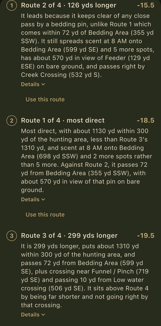
On Scout, a route report ranking 4 routes, least disturbance first: Route 2 of 4, 126 yd longer than the most direct, at −15.5; Route 1 of 4, the most direct, at −18.5; and Route 3 of 4, 299 yd longer, at −19.5, each with its note and a Details link.
  1. A: Higher is better. Route 2 leads, 126 yd longer than the most direct.
  2. B: Scout's extra: yards of the walk in view of a hunting-area pin, on bare ground.
  3. C: The most direct route, Route 1, ranks second.
Route report on Scout

It leads because it keeps clear of any close pass by a bedding pin, unlike Route 1 which comes within 72 yd of Bedding Area (355 yd SSW). It still spreads scent at 8 AM onto Bedding Area (599 yd SE) and 5 more spots, has about 570 yd in view of Feeder (129 yd ESE) on bare ground, and passes right by Creek Crossing (532 yd S).

From the report above, on a test ranch: the note on Route 2

In plain words: the top route is 126 yd longer than the most direct, but it never passes close to a bedding area, where the most direct route passes 72 yd from one. It still carries your scent onto a bedding area and 5 more spots at 8 AM, about 570 yd of it is in view of a feeder on bare ground, and it passes right by a creek crossing.

Route reports rank up to five walking routes to a stand or elk pin. Each stretch of the walk is judged at the hour you would reach it.

Pick Whitetail or Elk. Elk reports look out 800 yards instead of 300, and guard bedding, food, water and wallows instead of feeders.

Pro: 2 route reports a month. Scout: 30.

Pro and Scout, No AI

Which side

Approach wind shows, hour by hour, which of eight sides you can come in from so the wind and thermals keep your scent off a spot.

“Wind carries your scent to the SSW”

“Approach from: SE, S, SW, W”

From the app, on a test ranch

Scout, No AI

What you can see

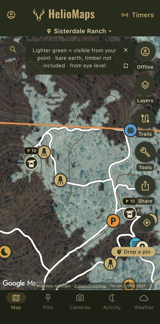
Line of sight on a ranch map over satellite imagery with contour lines, trails and stand pins: the ground visible from a chosen point is marked in pale green, with the app's note that it is bare earth, timber not included, from eye level.
  1. A: The app's key: bare earth, timber not included, from eye level.
  2. B: Green marks the bare ground you could see from the point.
Line of sight on Scout, on a test ranch

Line of sight marks in green the bare ground you could see from any point, out to 6.2 miles, from eye level or from a ladder or tree stand. Trees and brush are not included.

It runs on your phone.

Ranch overview

One write-up of your stands, cameras and rut

The ranch overview is a standing write-up of your stands, feeders, cameras, season and rut, written by Claude (Anthropic) when you ask for it. Season dates in it are Texas only.

Pro: 2 a month. Scout: 10.

What stands out: a heavy feeder program spread north to south, and only one camera watching all of it.

From a real report on a test ranch

It has six parts

  1. 1At a glance
  2. 2Stands and what they cover
  3. 3Feeders and cameras
  4. 4Season and rut ahead
  5. 5Worth doing this month
  6. 6What the data can't tell you

Elk country

From the stand to the ridge

Offline maps and pins are free across the US. Pin an elk, a bugle you heard, a wallow or a spring. On Pro or Scout, navigate to it over your own roads and trails, and when there is more than one way in, ask for a route report. It starts on Elk for these pins, and it needs a signal.

Pro: 2 route reports a month. Scout: 30.

Pro and Scout, No AI

3D map

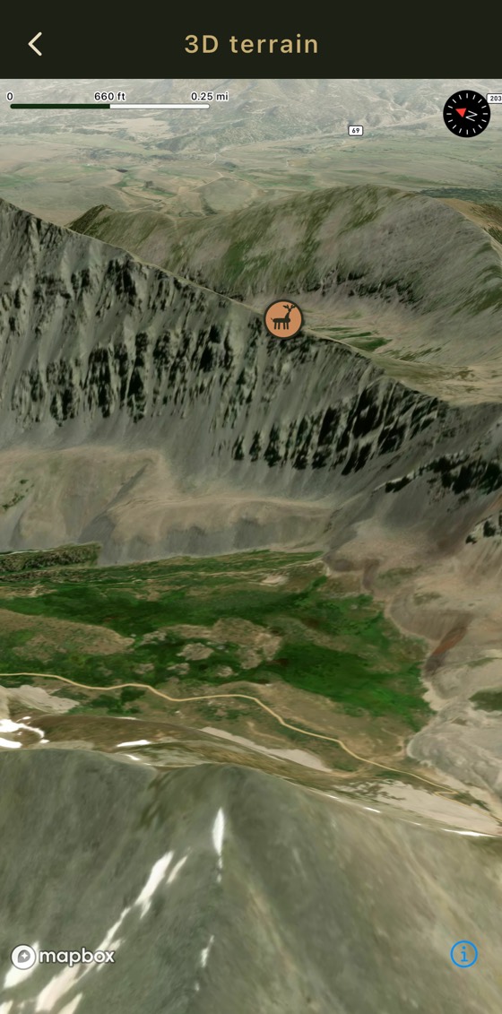
The 3D map in HelioMaps, titled 3D terrain: satellite imagery of a steep mountain ridge with patches of timber and snow, tilted at an angle, with an elk pin on the ridge line, a scale bar of 660 ft and 0.25 mi, and a compass.
  1. A: Your pins show in 3D, here an elk pin on a ridge.
3D map, on Pro and Scout

The 3D map lays satellite imagery over the shape of the ground, drawn a little taller than life, and tilts it, with your pins on it, so you can study a ridge before you climb it.

It needs a signal.

Scout, Coming soon, No AI

Elk terrain finder

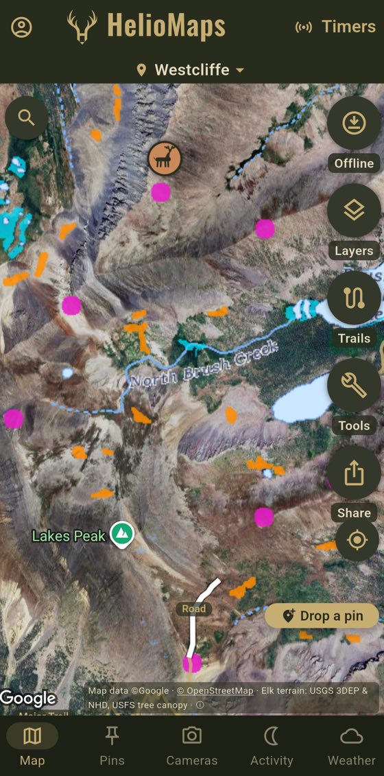
The HelioMaps map over satellite imagery of steep mountain ground with timber, a creek and a lake, an elk pin near the top, and the marks of the elk terrain finder layer. The credit line reads Elk terrain: USGS 3DEP & NHD, USFS tree canopy.
  1. A: A likely wet flat near water.
  2. B: A likely saddle: a low point on a ridge.
  3. C: A likely bench: a flat shelf on a slope.
From a test version of the app, in Colorado

Coming soon to Scout: a map layer that marks likely benches, saddles, wet flats near water and denser timber on north-facing slopes.

It is worked out from USGS elevation, water and land cover data and Forest Service tree canopy. Each mark is a likely bench, saddle, wet flat or patch of denser timber, not checked on the ground.

The Scout plan

Scout: a Best blinds report for nearly every day.

The same reports as Pro, and more of them: 30 Best blinds reports, 30 route reports and 10 ranch overviews a month, against Pro's 2, 2 and 2. Each Best blinds report ranks every sit in the next 24 hours. You ask for each one, and getting one needs a signal.

$75 a year

or $10 a month

Compare plans

Only on Scout

  • Route reports also count how many yards of each walk are in view of the hunting area, from a whitetail's or elk's eye height to yours, on bare ground.

  • Line of sight on bare earth (trees and brush not counted), as shown above. It works with no signal once the area is saved offline.

  • High points nearby marks up to five high spots within about 1.2 miles of a pin, each rising at least 50 feet above the ground around it. Tap one to run line of sight from it.

  • 25,000 cloud photos, against Pro's 1,000.

Reports a month, by plan

Best blinds, a month

Pro:2
Scout:30

Route reports, a month

Pro:2
Scout:30

Ranch overviews, a month

Pro:2
Scout:10

Free plan

The map is free

$0, no card.

The HelioMaps map over satellite imagery: brown contour lines labeled in feet, orange property lines, white roads, a trail and fences, and pins for blinds, feeders, parking spots, bedding areas, a creek crossing, a funnel, gates and a camp.
  1. A: Contour lines and their heights: Pro and Scout, online and saved offline.
  2. B: Your pins, and the roads, trails and fences you draw: free.
Online, on a test ranch in Texas
  • Offline maps across the US, on USGS imagery or topo. Save as many areas as you need.
  • Wind and weather for any pin: its own National Weather Service forecast, gusts and active warnings. Needs a signal.
  • County rut dates in 43 states, and Game Activity: moon and feeding times.
  • About 50 pin types, for whitetail, mule deer, elk, turkey, waterfowl and more.
  • Hunt assignments (who sits where, and when), a parking spot for each stand, and trail-camera photos on their pins. In Best blinds reports (Pro 2 a month, Scout 30), sits at a stand in the last 3 days count against it.
  • One public map link with your pins, roads, trails and fences.
  • Drive there: hands a pin off to Apple or Google Maps.
  • One non-personalized banner ad.

Plans

Free, Pro and Scout

Free

$0 no card

Includes
  • Offline maps across the US, as many areas as you need
  • Wind and weather for any pin, and county rut dates
  • About 50 pin types and drawing, with no limit on ranches
  • Hunt assignments, a parking spot for each stand and one public map link
  • Property lines and owner names: Texas and North Carolina
  • One non-personalized banner ad

Pro

$35 a year or $5 a month

Includes
  • 2 Best blinds reports, 2 route reports and 2 ranch overviews a month
  • Approach wind for any pin
  • Getting in and out: navigation over your own trails with up to 5 routes, track recording, GPX, 3D map and live location of your party
  • Terrain, public land and forest roads, saved offline with your areas
  • Share codes, co-editing, cloud sync and 1,000 cloud photos
  • No ads

Most reports

Scout

$75 a year or $10 a month

Includes
  • Everything in Pro
  • 30 Best blinds reports, 30 route reports and 10 ranch overviews a month
  • Route reports count how much of each route is in view, on bare ground
  • Line of sight and high points nearby, on bare earth
  • 25,000 cloud photos

Prices in US dollars. Paid plans are bought in the app through the App Store or Google Play.

HelioMaps Pro comes free for a year with any HelioTimer Pro. HelioTimer Pro feeder timers are coming soon.

Coverage

Where it works

Offline maps, pins and drawing
Across the US
Terrain and elevation
The whole US, including Alaska and Hawaii
Crop map
The lower 48
Wind and weather
Where the National Weather Service forecasts
County rut dates
43 states
Property lines and owner names
Texas and North Carolina. Texas parcels cover every county except Denton and Donley.
Legal shooting time and whitetail season dates by county
Texas only

Data sources

USGS The National Map (aerial imagery, topo and the National Hydrography Dataset), the USGS 3D Elevation Program (3DEP, about 10 m), the USDA NASS Cropland Data Layer (crops), the USDA NRCS SSURGO soil survey (soils), the National Weather Service and NOAA (forecasts and warnings), the Bureau of Land Management (BLM land and access easements), PAD-US (public land), USDA Forest Service Motor Vehicle Use Maps (forest roads and trails), TxGIO StratMap Land Parcels and NC OneMap (property lines and owners in Texas and North Carolina), the Texas Parks and Wildlife Department (Texas deer seasons), Google (satellite), Mapbox and Maxar (3D map), Stadia Maps and OpenStreetMap (road routing), and Anthropic (Claude, which writes the report notes and ranch overviews). County rut dates are credited state by state in the app. None of these agencies or companies endorse HelioMaps.

FAQ

Questions

Do I need feeders?

No. Best blinds also weighs bedding, food plots, funnels, water, scrapes and rubs, the walk in from your parking spot, thermals, fog, recent sits and the rut. Feed times count only from a paired HelioTimer Pro (coming soon).

Does it work for elk?

Route reports do. Pick Elk, and they look out 800 yards instead of 300 and guard bedding, food, water and wallows. Approach wind, line of sight and high points work from any pin. Best blinds uses whitetail rules.

Is it AI?

The ranking is done on your phone, by fixed rules. AI (Claude, by Anthropic) then writes a short note on each of the top five stands in a sit, and on each route, from the phone's facts, and it can't change the order. Nothing goes to the AI until you tap. Approach wind, line of sight and high points use no AI.

Will it give the same answer twice?

The ranking will: the same ranch data, forecast and time always give the same order. The written note may be worded differently.

Does a report work with no signal?

Getting a report needs a signal. Best blinds and route reports also need a recent forecast.

Non-personalized ads. No data sales.

Free shows one banner ad that is never personalized. Pro and Scout have no ads.

Read the privacy policy

iPhone and Android

Join the free beta

HelioMaps is not publicly listed in the App Store or Google Play yet.

Join the free beta

Downloads are paused while a new version is posted. Email for an invite code.

Email for an invite code